GPS Map Camera : Geo Tagging
(Premium Unlocked)Version: 1.8.4
By: GPS MAP CAMERA
Size: 63.00 MB
Release Date: 07 Nov 2025
Download APK How to Install APK FileBrand Name : GPS MAP CAMERA
Developer : GPS Map Camera
App Size : 63.00 MB
Email Id : support@gpsmapcamera.com
Version : 1.8.4
Privacy Policy : Click Here

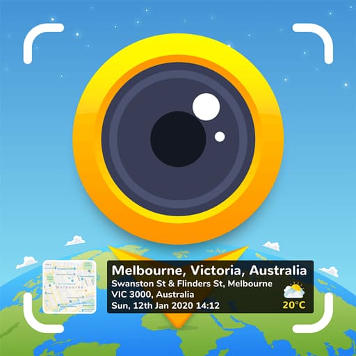
Capture and Relive Your Travel Memories with GPS Map Camera Looking for a way to preserve your travel memories with accurate location details? With the GPS Map Camera: Geotag Photos & Add GPS Location app, you can automatically add date, time, live map, latitude, longitude, weather, altitude, compass direction, magnetic field, and more to every photo you take.
📸 GPS Map Camera – Frequently Asked Questions (FAQ)
1. What is the GPS Map Camera app?
The GPS Map Camera: Geotag Photos & Add GPS Location app allows you to capture photos with detailed GPS information like date, time, live map, latitude, longitude, weather, compass direction, magnetic field, altitude, and more — all stamped directly on your pictures.
2. How does the GPS Map Camera work?
Once installed, the app automatically adds GPS-based data to your photos as you take them. You can choose from Classic or Advanced templates to customize your stamp format and display details such as map type, coordinates, address, and weather conditions.
3. How can I add a GPS map location to my photos?
Follow these simple steps:
✔ Install the GPS Map Camera app on your smartphone
✔ Open the camera and choose between Classic or Advanced templates
✔ Customize your stamp layout and format
✔ Capture photos — the app will automatically attach geo-location details to each image
4. What information can be added to photos?
You can include a wide variety of data on your photos, such as:
-
Date & Time
-
Latitude & Longitude
-
Address or Short Address
-
Live Map (Normal, Satellite, Terrain, Hybrid)
-
Time Zone (GMT/UTC)
-
Weather (°C/°F)
-
Compass Direction & Magnetic Field
-
Altitude, Wind Speed, Humidity, Pressure
-
Notes, Hashtags & Brand Logo
5. What is the difference between Classic and Advanced templates?
-
Classic Template: Automatically adds basic details like date, time, and GPS coordinates.
-
Advanced Template: Offers full customization — lets you choose map type, address format, coordinate type, logo, hashtags, notes, and environmental data such as weather, wind, and humidity.
6. Can I manually edit or add location details?
Yes. The app allows both automatic and manual data entry. You can manually add or modify location, address, or coordinates to suit your needs.
7. What camera features are available?
The GPS Map Camera offers an enhanced camera experience with:
-
Grid & Ratio options
-
Front/Selfie camera
-
Flash, Focus, Mirror, and Timer settings
-
Scene modes & filters
-
Dash camera level & capture sound
-
Night HD mode for clear low-light photos
8. Who can benefit from using this app?
This app is perfect for:
-
Travelers & Explorers: Documenting trips with real-time GPS stamps
-
Real Estate, Architecture, and Infrastructure Professionals: Capturing location-stamped site photos
-
Event Organizers: Adding live location to event photos
-
Field Workers: Recording data with GPS notes
-
Bloggers & Influencers: Adding authenticity to travel, food, or fashion photos
9. Why should I use the GPS Map Camera app?
Because it helps you:
-
Capture and preserve travel memories with accurate map stamps
-
Share geotagged photos with friends and family
-
Keep a location-based record of professional or personal activities
-
Add timestamps and environmental data to your photos for authenticity and organization
10. Does the app support adding my brand logo or notes?
Yes! You can upload your brand logo, write custom notes, and even include hashtags directly on your photos for branding or social media sharing.
11. Can I share my GPS-stamped photos?
Absolutely. You can easily share geotagged photos showing your current or chosen location with your friends, family, clients, or colleagues through social media, email, or messaging apps.
12. How can I get started?
Simply download GPS Map Camera: Geotag Photos & Add GPS Location, open the app, and start capturing your moments with real-time GPS data.
13. How can I share my feedback?
We’d love to hear from you! After using the app, please rate and review it to share your experience and suggestions.
Popular Apps

.webp)
.webp)


New Apps
.webp)

.webp)

.webp)
.webp)
.webp)
.webp)
.webp)
.webp)
Latest Apps
.webp)
.webp)
.webp)
.webp)
.webp)
.webp)
.webp)
.webp)
.webp)
.webp)
.webp)
Total Reviews: 1
5 ★
4 ★
3 ★
2 ★
1 ★
Top Apps
-
.webp) Endel: Focus, Relax ⭐ 4.7
Endel: Focus, Relax ⭐ 4.7 -
.webp) Zen: Relax, Meditate ⭐ 3.7
Zen: Relax, Meditate ⭐ 3.7 -
.webp) Accupedo Pedometer ⭐ 4.4
Accupedo Pedometer ⭐ 4.4 -
.webp) Doodle Art: Magic Drawing App ⭐ 4.1
Doodle Art: Magic Drawing App ⭐ 4.1 -
.webp) Word Cloud ⭐ 4.1
Word Cloud ⭐ 4.1 -
.webp) PeakFinder ⭐ 4.3
PeakFinder ⭐ 4.3 -
.webp) Pass2U Wallet - Add store card ⭐ 4.0
Pass2U Wallet - Add store card ⭐ 4.0 -
.webp) Travel Tracker - GPS tracker ⭐ 3.8
Travel Tracker - GPS tracker ⭐ 3.8 -
.webp) OruxMaps GP ⭐ 4.0
OruxMaps GP ⭐ 4.0 -
.webp) PeakVisor - 3D Maps & Peaks Id ⭐ 3.9
PeakVisor - 3D Maps & Peaks Id ⭐ 3.9 -
.webp) Planes Live - Flight Tracker ⭐ 4.3
Planes Live - Flight Tracker ⭐ 4.3